Monday, September 23, 2019

Georgian Bay, Part 5: Back Home

If you've read the first four parts of the Georgian Bay story you should be well prepared for this quiz:

1. Our trip back to Chikanishing featured
a) Wind
b) More Wind
c) Exceptionally Strong wind
d) a, b & c

Answer key: 1. d

Yes, our last day of paddling was once again a windy one. Winds peaking at about 28 MPH, with gusts well into the 30's, coming from due west (so again, right in our faces for most of the trip) and channeled through the narrow inlet to make the wind seem even stronger. The kind of wind where you keep looking at the shore to reassure yourself that you're actually moving forward. The kind of wind where you don't dare miss a paddle stroke for fear of losing what little forward momentum you have. This was small craft advisory bordering on gale force stuff, and on a regular day it's the kind of weather where I'd stay home.

No longer hyper-concerned about conserving phone battery power, I was running Strava and so have a track file
We packed and loaded our boats for the last time (easier now, with little food left to pack) and headed first north up Mill Lake then turned west into the wind. Oh, yes - this was the weather I had wanted to avoid by heading home early. And what was demoralizing was that we knew the worst would come at the end. When we did the windy transit from campsite #2 to #3 we hit the worst of it going up Beaverstone Bay and knew that calmer waters awaited us once we rounded the bend into Collins Inlet. Here it was the opposite. We struggled against the wind all day in the relatively protected waters of Collins Inlet (lots of wind, but little wave action) but knew that we had some open water to cross at the very end to get back to Chikanishing. Also, my GPS crapped out again and so did Tom's so we had only Béla's older model to guide us. I was doing my best to identify where we were by looking for the geographic features we were seeing on the map, but in a straight narrow channel there aren't that many distinguishing features.
Heading back

Lunch break

The odyssey comes to an end

The struggle against the wind put us in moods ranging from determination to resignation to just plain foulness. I think Tom was eager to get back at this point and was urging us on, but I insisted on a lunch and rest break before we hit the open water. We found a barely landable area where we scrambled ashore to eat something, stretch out and resting a little. After that, we got a little break as the wind died down for a bit, and so we made better time. Then it was the home stretch, where we emerged from behind the protection of Phillip Edward Island and were open to the immensity of Georgian Bay. The waves were big. Three footers at least, maybe approaching four. Coming at us from our left side (from the open bay) so harder to deal with than head-on. It was a wild ride. Fortunately, we only had to deal with it for about a mile. I was still trying to navigate by map and was off in terms of where I thought the opening to Chikanishing Creek was, but fortunately Béla called it right. We made the turn into the creek at just the right spot and breathed a sigh of relief. Just a few hundred yards of smooth water and we were back at the launch. As we were coming in we passed several groups heading out including two people in a canoe (they came back quickly) and a family in kayaks, including young kids in their own boats. We didn't see the family come back - I hope they didn't run into trouble in the rough water.
Kayakers happy to be back
We packed the cars and drove over to the campground where we stole showers (I think the showers were intended only for campground users, but we didn't care). Oh, it felt good to have a real shower - and they were nice, hot ones - even when I realized that I had forgotten to bring in a towel and had to dry myself with my dirty paddling clothes. Then, it was off to the long trek home. Tom and I stopped back in Parry Sound for dinner (vegan pork BBQ made with jackfruit!) then achieved our goal of making across the border into the U.S. before stopping for the night. Then the next day, we were homeward bound.
Interesting car in the Chikanishing parking lot (Vermont licence plates!)

View at dinner in Parry Sound
Lessons learned:

1. I really like Jen's approach of mixing up soup in a Thermos at breakfast time and having a hot lunch.

2. You can never have too much redundancy. Who would have thought that two of our GPS receivers (the only two with detailed maps of the area!) would crap out at the same time? My chance decision to leave a serving spoon in my food kit really helped when the majority of our cooking tools got accidentally left in the car (though we crafted a nice stirring stick that we carried with us from camp to camp). And it's a good thing we had two water filtration systems with us, as one failed mid-trip.

3. You have to find ways to accommodate the range of the group's paddling endurance, comfort level and speed limits.

4. Figure out the minimum amount of clothing you need, then reduce it by a third.

5. Label everything. Weeks after the trip we're still exchanging emails saying, "Hey, I have an extra X. Whose is it?"

6. Leave No Trace is not as bad as you'd think, and it really impresses your friends back home in terms of what a camping badass you are.

7. Don't worry!

This entry covers campsite #3 back to Chikanishing


Georgian Bay, Part 4: Up Into Collins Inlet

Day 8 (Thurs): Readers of this adventure already know that wind is the defining element of paddling on Georgian Bay. The forecast for Thursday through Saturday was unsettling enough to catch the attention of even a non-worrier like me. I thought it might be prudent to return to the put-in early ahead of the weather; however that idea was dead on arrival when presented to the larger group. So, off we went into a few more days of wind and rain.

Thursday was our biggest move of the trip, from the southern side of Phillip Edward Island around the east side, up Beaverstone Bay and then around the top of the island into Collins Inlet. I apologize to readers of this blog that there are a confusingly large number of bays to remember. All along we were in Georgian Bay (big), but were paddling through many smaller bays formed by Phillip Edward Island. The best I can suggest is that the curious reader peruse the map.

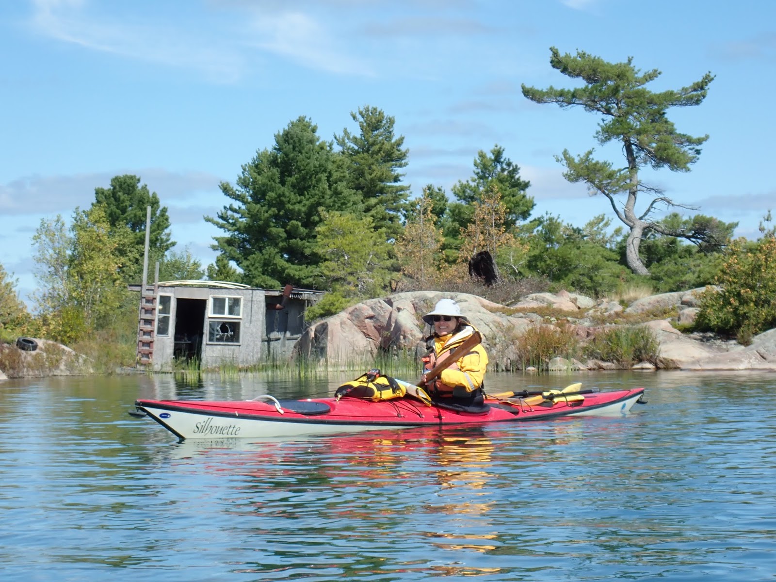
We packed the boats and said goodbye to our sweet "Limerick" campsite on Crume Island and headed out. We initially found ourselves paddling calm water, shielded as we were from the wind, which was blowing from the northeast (we had the landmass of the island protecting us from the wind). The first miles were familiar territory, as we had paddled them the day before. Once we turned the corner into Beaverstone Bay, however, it was a different story as we found ourselves kayaking straight into a fairly strong wind. Paddling into the wind is less nerve-wracking than any other direction, as waves coming at you head-on don’t do nasty things like try to knock you over or spin you off course. Rather, paddling into a headwind is just tiring, like paddling though molasses. Everyone handled it well, but we definitely appreciated a snack break we took in a cove of a small private island, which allowed us to stop paddling for a few minutes without losing ground by being pushed backwards. The cove was home to a private home, complete with totem pole (note to self: in next life, arrange to own a private island).

Around the corner into Beaverstone Bay

About two thirds of the way up Beaverstone Bay we started looking for a place for a lunch break. Unfortunately, the islands in the area had pretty steep shorelines making landing impossible and we had to hunt for a while before finding a small hunk of rock on which to perch - just about big enough for five of us to pull our kayaks out of the water and perch for lunch, and on the other side of a boulder there was privacy for bathroom needs. Eating lunch on a rock, as we did several times on this trip, is something I enjoy, though I understand that it's not everyone's idea of a dream vacation. I think I've passed this kind of sense of adventure on to Ted, as he recently wrote in his own travel blog about having happily eaten tortellini from a Ziploc bag while crouched in a Porta-potty (freshly cleaned, fortunately) taking shelter from a rainstorm during his hike on the C&O and GAP trails. Both tuna on a rock and tortellini in a toilet are the kind of crazy stuff that make you smile but which bring looks of horror to your friends' faces when you tell them about it.
Into Collins Inlet
Paddling in the confines of Collins Inlet
Me

After lunch the going got a little easier, as the wind seemed to let up a little bit. Or maybe it was just my drug-fueled perception of it, as at lunch break I had ingested a miraculous performance enhancer known as caffeine. Since my surgery I've kicked the daily maintenance caffeine habit and instead use it only as needed as a performance-boosting stimulant. About 70 miles into the 100 mile bike ride I did last year a café latte gave me a boost which took me through the rest of the miles, and during lunch on the rock I popped a caffeinated GU gel packet which I had stashed in my PFD for just such purposes. Man, a good shot of caffeine has a Popeye eats-spinach kind of effect on me. Woo Hoo! Bring on the miles!

Energy gel packets such as the one I had stashed in my PFD are popular in the cycling world. In preparation for this trip I bought a few at the Laughing Lizard bike shop and cafe in Herndon (incidentally, the same place I got my latte on my century bike ride). I went in, ordered a decaf latte, making my usual fuss to ensure they make it decaf: “Make sure it’s decaf.” “This is decaf, right?” You should have seen the puzzled look on the guy’s face when I asked him to ring up my decaf “this coffee is decaf, right?” decaf latte and then threw a couple of high caffeine energy packs on the counter as part of the purchase.

Beaverstone Bay offered some lovely scenery in the form of typical Georgian Bay pink glacial pink granite islands and northern woods. Three quarters of the way up the bay we were all pretty tired but our spirits were buoyed when we started to hit channel markers, which confirmed that we were approaching Collins Inlet. We were happy to be getting near the end of our slog into the wind, and indeed when we rounded the corner into the inlet conditions calmed down quite a bit and the scene changed from open water to a narrow body of water lined by high rock cliffs.

Our next challenge was finding a campsite. The paddler’s map has campsites marked, but there’s no indication of which are big enough for a group of five kayakers. We rejected the first one outright as being to small, vertical and exposed, which meant paddling another mile or two to the next one in Mill Lake. We rejected that one for the same reasons. The third campsite showed some promise, but from the water seemed small as well, though the following day we stopped to talk to a group that had come in behind us and camped there. They fit eight people on the site, and while they said it was a tight fit I guess the campsite was bigger than it looked from the water. By this point the water bladder on the back of my PFD was empty and my other bladder was achingly full. We were also running out of sites so even though I'm not generally one to worry, I was starting to get a little anxious to about finding a campsite. Fortunately, Suzanne “had a good feeling” about the site on Archers Island. The site had a tight landing spot, but we got out and found it to be a lovely campsite. We subsequently realized that, as with our previous site, this was one of the sites marked in the Hodnett Canoe Guide. Clearly the Hodnett people had selected the best sites in the area.
Third campsite
We made camp, taking care to set things up carefully. Rain and wind were once again in the forecast for Friday and we wanted to be well battened down in advance of the storm.

I don't remember, but I think it might have been Thursday that I finally took a shower. Tom loves a shower while camping and he loves the "camp craft" of rigging up camping devices. Over the years he's progressed from a solar sun shower to a handheld electric shower (not exactly this one but similar). We set up a collapsible bucket, which gets filled with a combination of lake water and heated water. You dip the hose into the shower bucket and click a button on the nozzle and presto, ... a somewhat warm shower! I had demurred on using the shower when he set it up at the previous campsite because I hate being cold and would rather be stinky than stand naked in a cold breeze, my shivering relieved only by an occasional blast of lukewarm water. However, by Thursday I had gotten to the point where I could no longer control my stench with wipes and so finally broke down and used the shower. Despite the chilliness of the experience it felt really good to get clean. I will say that some group members are happy to bathe themselves in the cold water of the lakes when we travel. The amount of screaming that goes on when they do this usually reconfirms my choice to remain stinky rather than cold. The only time I'll dip myself into a cold lake is if we get a really nice warm, sunny day - of which we had none on this trip.

Can you spot Béla in the water? He's doing something I'll never do - immersing himself in the cold water of Georgian Bay (this is back at campsite #2)
We had Jen’s Gado Gado for dinner while we sat on the point of the island, the sunset to our left and the nearly full moonrise to our right. I drank the last of my bourbon. My food bags were getting pretty light. Must be nearing the end.

Sunset to our left ...

... moonrise to our right

Day 9 (Fri): Our last full day! Well, full day in terms of hours, in that there are still 24 of them, but half day in terms of activities. We knew that bad weather was going to roll in once again and that we would be forced to spend the afternoon tent-bound. We got on the water early to give us time to have a decent outing before the weather rolled in around noon. On our way through Collins Inlet we had passed the abandoned logging town (also known as Collins Inlet) but we were on a hunt for a campsite and didn't stop. We paddled back over to that area where we saw the remnants of the old logging town, which was abandoned in the early 20th century once the area was logged out, and the more recently closed Mahzenazing River Lodge, which appears to only recently have been abandoned - as of 2017, when my paddling of the area map was printed, it was apparently still a going concern (Mill Lake Lodge on the south side of Collins Inlet is still an active business - the only commercial business we saw the whole trip). Along the north side of the inlet you can spot various remnants of the logging days: iron rings anchored in rocks which once were used to hold logging booms in place (Jen guessed the purpose of the rings - later confirmed from the paddling map), remains of pilings from the logging camp’s loading docks, etc. We toured Sawdust Bay, once no doubt aptly named but now returned to a seemingly untouched natural state.

On the way back the wind picked up pretty fiercely, occasionally attempting to spin our boats around. Bela, who in general is the best navigator of the bunch of us, somehow managed to almost get us lost on the way back - not easy to do when you’re paddling a 1/4 mile wide channel. But cooler heads and GPS prevailed and we found our way back with no issues. We timed our trip about right: it was starting to rain as we returned to camp 11ish. All of us except Tom ultimately hunkered down under the tarp for a while and had lunch together. For me it was the rare treat of turkey jerky (not a lot of fat, but I still avoid it because it's loaded with sodium - it was a nice change from my usual choices of tuna and peanut butter), along with a squeeze pouch of fruit mush, week-old tortillas, and a fruit bar. Plus some chickpeas and dried “imperfect” mangoes provided by Suzanne and Béla respectively. Fine dining!

Remnants of logging days
Abandoned logging camp building
Beaver lodge 

Suzanne paddles past abandoned buildings

This tractor isn't going anywhere
After lunch it was another afternoon stuck in the tent in the rain. Here’s a little snippet of the fun things I did while stuck in a roughly 3 x 6 ft. space all afternoon: took my phone off airplane mode to see if it would connect. Spent a few minutes in that frustrating state where the phone says “3G” but really isn’t connecting at all (there was only one specific spot on the island where you could stand and really get connectivity). Put the phone back into airplane mode. Took my headphones out so I could watch some downloaded Netflix. Noticed that the ear buds were kind of gross. Figured out how to gently remove the squishy ear bud tips. Blew the crud out of them by blowing on them, transferring the ear crud first to the screen of my phone, then ultimately to the tent floor. Wondered if I had accomplished anything in terms of increased cleanliness by transferring my earwax from earbuds to tent floor. Switched out of airplane mode to see if connectivity had miraculously improved while I was cleaning my headphones. Spent more time in zombie 3G mode. Put the phone back into airplane mode. Watched Netflix. Read a book. Peed into a bottle to avoid going out into the rain. Noticed that the tent had begun to take on a little bit of that public restroom smell. Vowed to go outside the next time I had to pee. Took pictures of myself making faces. Watched a caterpillar crawl up the outside of my tent. Thought about how I could be showered and halfway home by now. [Note: this paragraph was written in my tent on Friday. As it reflects my frustration with being stuck in the tent in the rain, I have left it pretty much as initially drafted].

After a few hours of rainy solitary confinement in a tent, caterpillars become pretty interesting entertainment
If you are bored enough, making faces into the phone is almost as entertaining as watching caterpillars
I did have the thought that the rainy days gave me a chance to experience how normal people spend their vacations. I mean, if I told people I had spent my vacation reading, catching up on Netflix and napping by a beautiful lake they would have thought it sounded like perfectly normal, relaxing downtime. As long as I left out the peeing into a bottle part. And the pooping into a bag part. And the sleeping and eating on a rock part ...

This entry covers 2nd campsite to 3rd campsite and other explorations in Collins Inlet (the channel across the top of the island).


Sunday, September 22, 2019

Georgian Bay, Part 3: In Bear, Deer and Moose Bays

Day 6 (Tues): So, there's this joke that goes like this:

A waiter in a restaurant is checking on his tables. First he goes up to a table of businessmen and asks, "Is everything OK?" Satisfied that they have no issues with their meals, he goes on to his next table, which is occupied by a group of visiting New Yorkers. The waiter approaches them and asks, "Is anything OK?" See, the humor is in the change from "everything" to "anything" - the assumption being that while most diners will find the meal satisfactory, New Yorkers are going to complain about just about everything. What people from flyover country don't grok is that kvetching is just New York small talk, the equivalent of square-staters talking about the weather or tips for baling hay, or whatever it is they talk about.

The group had labeled me a "worrier" because I was forever going on about bears. They for some reason got the impression that because I kept saying that I would be happy not to see any bears, that I didn't want to see a bear. Not true! I would have been perfectly happy seeing a bear from a safe distance. What I didn't want was to bump into a bear in or near camp, as had happened on the group's previous trip to Georgian Bay. I didn't want a bear going through my food, using my toothbrush, or scattering my meds, that's all. They have me all wrong - I am not negative. In truth, I am a little ray of sunshine.

Tuesday both we and the bears hunkered down in our respective (fortunately non-overlapping) camps. As the forecast had predicted, it was a stormy day. We could see some really big waves out on the bay and the water was churning even our protected cove. At peak, the wind was blowing 25 MPH with gusts about 30, and the waves were in excess of 5 1/2 ft. high. Now, I can handle 3 ft. and could probably stay alive in 4 ft., but 5+ ft. breaking waves and 30 MPH gusts - that would be terrifying. So we hunkered down. In the old days, that would have meant a musty paperback and a lot of napping, but in the era of do-it-all cell phones, I had books and videos, and thanks to a compact external Bluetooth keyboard (kudos to Ted for suggesting this device) I could even work on this blog. The rain fly on my tent was ever so slightly off center and so I got a little water in one corner of the tent but otherwise stayed high and dry.

Attempting yoga in my tent
Hanging out under the tarp

The good news was that the rain moved out somewhat earlier than forecast, allowing us to emerge from our cocoons and socialize under the tarp we had strung up, as well as do a little exploring around our island. I had dinner duty once again. This time is was gnocchi, a perennial Jesse camping dinner crowd-pleaser, but with a new sauce - tomato powder, dehydrated mushrooms and kale, and Italian spices. Oh, and topped with freshly grated parmesan cheese. We eat pretty well.

Day 7 (Weds): This was a weird day for me. If you remember, Suzanne had some 24 hour crappiness our first day out, which caused her to skip my delicious burrito dinner. Well, on Wednesday I exhibited a mild version of the same thing. We decided to go out for a local paddle and scout our route for the next move. There's a channel that connects Bear, Moose and Deer Bays, providing a protected route for the beginning of our next campsite move and, guess what, the forecast was for high winds on our move day, so we wanted to see how far we could get without venturing fully out into the big bay. So, we set out exploring through the channels and islands around us and around Hincks Island, which would take us to the southeastern-most corner of Phillip Edward Island. Immediately on setting out I felt really tired and like paddling was a lot of work, even though we had empty kayaks. I commented to the others about how worn out I felt from the paddle the day before but thought nothing more of it. I had no symptoms other than feeling low energy.

We paddled a modest distance of maybe six miles (guesstimate). No heavy weather. When we got back to camp, though, I was beat. I immediately crawled into my tent and slept for 20 minutes or so. Then to make matters worse, I walked up to Tom's campsite. Tom likes to have some personal space and usually camps a little bit away from the rest of us. This time he was up on a higher plateau which required a little bit of effort to get to, and by the time I got back from his campsite I was dazed - all I wanted to do was collapse into my chair and stare into space. Still, I didn't really think anything was up.
Paddling the small bays
Signs of autumn in Georgian Bay

Near Hincks Island we saw our first navigational buoy

This smiling face is some sort of navigational marker

Tom using his kayak sail
Honestly, I'm a little fuzzy on the details of our Wednesday paddle, but apparently we ate lunch on a rock again ...
... and saw a frog

We had dinner and then were hanging out in the common area trying to get a fire going. It was a cool evening. All of a sudden I started to shiver, and all I could think of was getting warm. At about 7:30 I got up without even saying anything and bolted to my tent where I crawled into my sleeping bag. And the next thing I knew, it was 11 PM. I woke up, got undressed & got ready for bed, crawled back into my sleeping bag, and slept through 'til morning. Fortunately, 11 hours of sleep seemed to do the trick and the next day I felt fine.

This entry covers time at the 2nd campsite and paddling in the small bays around it

Georgian Bay, Part 2: Across the bottom of Phillip Edward Island


Day 4 (Sun): The Canadian Shield is a large area of extremely ancient rock sweeping across much of northern central Canada and into the Adirondacks in the United States. Representing some of the oldest rock formations on earth, the rock of the shield has been worn down by literally billions of years of change and was scrubbed clean of vegetation in successive ice ages. As a result, areas within the Shield have a rugged and ancient felling beauty. The Georgian Bay area has a collection of islands large and small, all made up of exposed craggy pink granite and quartz, topped in some places with pine and birch trees that cling tenaciously to thin soil atop the rocks. The scenery reminds me of Scotland, where they refer to small (too small to be habitable) rocky islands as "skerries".
Some big skies on Georgian Bay!

Kayaking past a "skerry"

Example of Georgian Bay rock formations
We knew that wind would be a major factor in this trip. Georgian Bay is a large body of water alongside Lake Huron (some say it deserves to be considered a Great Lake all on its own) and the huge "fetch" (large open surface area of lake across which winds can blow) means that winds can really build up force. Amazingly, despite being in a wilderness area we had cell coverage throughout the trip and so were able to keep on top of the weather. The forecast told us to expect high winds Sunday morning, settling mid-day. As a result we took our time eating breakfast, puttered around camp and spent some time exploring our little island. There were a few campsites on the island, though the others were all vacant. Alas, we never found the "thunder box" mentioned in a blog we had found about kayaking in the area.
First campsite
We went out to explore the remainder of the area of The Foxes in he afternoon. Not too eventful a paddle. The winds had indeed settled down, and it was a nice outing. The Foxes appear a little different than a lot of Georgian Bay in that they are more forested and there are fewer "skerries" (having introduced the term, I'm going to keep using it). So, it was a good paddle but we felt it wasn't a full-on Georgian Bay experience.

In the evening it was Suzanne's turn to make dinner. Unlike my science experiment approach to dinners, Suzanne has some tried and true recipes we all enjoy. Tonight it was a tuna/pasta/olive/feta dish. We assign dinner nights by random draw, and getting an early night is a good thing, as once you've made dinner you've reduced the volume and weight of food in your kayak. We always hang our food to keep critters away from it, and in Georgian Bay, which is reputed to have a large bear population (we saw scat but no bears), we took extra precautions of smell-proof bags inside of kevlar bear-resistant bags. All this bagging is something of a pain; all the more reason to be happy as you use up food - less bagging and unbagging to manage.

Speaking of bears, on top of everything else, we realized that we were camped amidst lots of wild blueberry bushes, which we figured were sure to attract bears into our camp (they did not). The woman at the outdoor store in Parry Sound had said that it had been a bountiful year for berries and acorns and so the bears were fat and happy enough that they weren't bothering campers - but you never can be sure.

Delicious bear attractants right outside my tent
Day 5 (Mon): Let's talk about poop. Most of the places we camp on our trips are somewhat developed in that you can expect that there'll be some sort of primitive toilet (outhouse, thunder box, etc) available. This was the first trip I've done where there were no facilities whatsoever. Further, given that the the terrain was bare rock with at most a thin layer of soil, we couldn't even bury our waste - we had to pack it out. "Why not just leave it? Animals poop on the ground," someone asked me. Well, animals distribute their droppings throughout the woods, whereas campers stick fairly close to campsites. As an example, if you figure that Georgian Bay campsites are used about half the year, and assume that they're occupied about half the time during those six months, that your average group has 2-3 people, each of whom poops once per day, late season campers like us would encounter about 200 piles of human waste at a campsite. Not the ideal wilderness experience. So, I learned to use, if not to love, the wag bag. Monday was the first time I had to face this particular task, and I felt almost like crying as I headed into the woods. Truth be told, it wasn't as bad as I had expected - actually less gross than picking up after a dog, as it involves less intimate contact with the offending substance. I used a commercial product called a Biffy Bag; my understanding is that at least one of our group used Ziplocs with kitty litter in them. Unless those were some really big Ziplocs, kudos to my traveling companion for his precision aim.

Then there's the question of how you carry the load. The wag bags themselves include a thick outer zip top pouch, which is supposed to contain the contents, but let me tell you, by itself it doesn't contain the smell. Some people put their used wag bags into a dry bag, while others just double bag everything using Ziplocs or trash bags. I decided to make a poop tube, capping the ends of a length of PVC pipe (extra pipe I had on hand in my shop) and using it for storage. The good: really effective smell containment, easy to carry behind the seat of my kayak. The bad: heavy, and takes up constant volume. In contrast, people using soft-sided storage found that they had a nice balance - as picked up space from using up food, it created more volume for their poop storage, which went up as the food went down (imagine that!).

Sorry to run on about this topic, but it was on Monday that I had my first wag bag experience. Fortunately, (TMI warning!) my digestion can get irregular when I travel, and I used only two more bags during the full week of camping.

But enough about that. In addition to pooping, we also moved camp on Monday. Packed everything up, slid our way down the hill with all our gear down to the boats, and went off in search of our next campsite. One thing was for sure about this trip, if we had a big move to make it was going to be windy. Another thing, the land of Phillip Edward Island and its environs is "crown land" - undeveloped land open to camping. We had a map with campsites marked, and we had a guide from a local canoe outfitter company listing campsites, but there really are no formally designated campsites - rather, the maps mark places that are known from experience to be good for camping, that is, they have places to land boats and some flat areas. However, there's no formal guide to the campsites and not all of them are amenable to groups with five tents, so setting off for the next campsite meant setting off exploring, hoping to find a suitable place to camp in the desired area.
Moving sites
Exploring an abandoned structure
Navigating

Typical lunch stop while paddling
Lunch stop

"Limerick" campsite had some awesome views

Kayak landing, "Limerick" campsite

Moon rise

Local resident after a meal - some kind of garter snake?

Unfortunately, even though I had restored my GPS to working order by Monday it doesn't seem to have recorded track files so I can't show where we went, but we basically headed due east from Martin's Island, taking us across the bottom of Phillip Edward Island, scootched around the top of Hamilton Island, then went hunting for campsites in the triple bays of Bear Bay, Moose Bay and Deer Bay (fake news! despite theses names, we didn't see a single moose, bear or deer). After a choppy 5-ish miles (guesstimate) it was nice to get into the protected waters of the bays, where there were at least ten campsites marked. We knew that a big storm was supposed to be coming our way and so we wanted to find a campsite that met Tom's requirements (big, open flat rock - typical Georgian Bay), met others' requirements (set back from the open water to provide shelter from the storm, some trees for wind break, hanging food, and privacy for the aforementioned pooping), and was big enough to hold all of us comfortably. We quickly found that one of the canoe outfitter's marked sites met these needs, but still spent a bunch of time examining other sites before returning to the site on Crume Island the outfitter had labelled "Limerick". Clearly this was a well used site. You can tell this in Georgian Bay by the rock circles. Without enough soil to hold tent stakes, you instead secure your tent by tying it to big rocks. If you get to a site and it has circles of big rocks, it means someone has pitched tents there before. This site even had graffiti from 1971. It met all of our needs and more. It was a really good site. We made camp.
Unpacking the kayaks at campsite #2

My tent at "Limerick" campsite on Crume Island - note the rocks

We did have a chance to make a campfire at Limerick

Have I mentioned the views?

Alfred and Mary were here ... in 1971!
Paddling past a "skerry"

This entry covers day paddling in "The Foxes" around the first campsite and the move to the 2nd campsite.


A Tale of Four Jess's

 Jesse is not all that common a name, and so unlike the Toms, Davids, and Bobs of the world I don't run into much name confusion. So it ...