Mathews is one of the less developed counties in Virginia, so rural that it may not have even a single traffic light. I say "may not" because whether it does or not depends on whether you count the lights at the end of the swing bridge to Gwynn's Island, as mentioned in this quote from the county web page: "Mathews County still does not have any traffic signal lights. However, there are lights placed at either end of the swing span bridge to Gwynn's Island that could be considered traffic lights by some." As just about everyone knows, Mathews is also known as the daffodil center of the Middle Peninsula and was the home of Sally Tompkins, the only female officer in the Confederate Navy. Captain Tompkins, I salute you for your groundbreaking accomplishment, even if it was in the service of treason against the state. Oops, my Yankee roots are showing again.
Mathews County has developed a set of water trails - planned paddling routes, much like hiking trails. A neat set of maps is available at the Bay Gateways web site. I had studied and plotted waypoints for two: the Piankatank River Trail and the Winter and Horn Harbor Trail. It was hard to resist a river with a name like Piankatank (a Powhatan Indian word meaning "river in place of no traffic lights") but since the weather was calm we opted for the more remote, more exposed Winter and Horn Harbor Route, which included a section in the Chesapeake Bay. The launch point was at Garden Creek Landing, a somewhat grandiose name for what turned out to be nothing more than a road that ended at a sand dune. Apparently the end of the road is a little bit of public Chesapeake Bay frontage sandwiched between private property to the left and right. It seemed quite remote to us but was hardly unknown - someone was there combing the sand with a metal detector when we arrived, and a small group of locals was there enjoying the beach when we returned.
We launched into the Bay and headed due south along the shoreline. The Bay was pretty calm, though an occasional wave broadsided us, dumping across our boats. Good bracing practice. We followed the water trail route into the northern end of Winter Harbor. What looked like a small opening on the map turned out to be almost half a mile wide and we poked along looking for the narrow harbor opening for quite a while before realizing we were already in the harbor. After crossing the northern harbor we followed a narrow series of passages to the harbor's southeast corner. It was during this time that I realized the challenges of navigating on water using a GPS loaded with the "roads and recreation" mapset. Rob's GPS, loaded with the marine mapset, offered a much better representation of the facts on the ground (or on the water). So we had my GPS, loaded with the route waypoints but showing us paddling over land, and we had Rob's GPS with the good maps but no route waypoints. No problem; we put our egg-like heads together and figured our way through. The stretch through Winter Harbor was as beautiful as kayaking gets: tall grasses, pretty water, blue skies, bird life aplenty. Being on the water can be so wonderful that one wonders why Noah was so happy to see the dove bring back the olive branch indicating the reemergence of dry land.
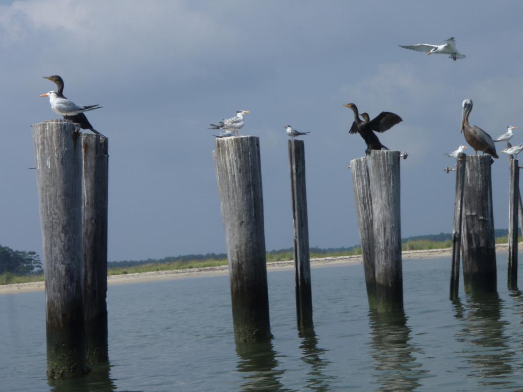 |
| Birds on pilings in the Chesapeake Bay near Garden Creek |
Before long we reached the Winter Harbor channel, identified by a series of red markers, at which point it was time to decided whether to explore the fingers of Winter Harbor or whether to head back into the Bay and paddle around into Horn Harbor. We chose the latter, first taking a bit of a break on a beautiful and desolate sandy strip just outside Winter Harbor (due south of red buoy 4A, in case you want to visit). While I knew we were just around the bend from some houses inside the harbor, it felt like we were at some incredibly remote desert island. We beached the boats and dunked ourselves in the water for a bit, gaining a little refreshment from the bathwater warm sea. We also walked around and took pictures. As with the prior day, I was just reveling in being in such a wonderful and different place, wearing a PFD (life jacket) rather than a Blackberry.
 |
| Cooling off in the Bay near Beach Point |
We climbed back into our boats and paddled into Horn Harbor looking for Peary Landing as a place for a lunch break. By this point it was quite hot out and we were hoping to find some shade in which to take a break. Peary Landing turned out to be elusive - it may be another of those hard to discern end-of-the-road public landings, but we did find a cove that offered a place to get out and get shade under a stand of evergreens. The shoreline was guarded by an army of little fiddler crabs, ridiculous looking things each with one huge claw. They looked like they were wearing the crab version of those giant foam hands you see fans wear at ball games. Fortunately the Lilliputian crustacean defenders retreated as we approached and kept their distance as we feasted on peanut butter sandwiches, tuna, Toblerone and, in my case, a lukewarm Coke Zero.

Some of the inspiration for this trip came from Kayaker Ralph's recent Chesapeake Paddler's Association trip to the same area (well, also I had for years wanted to check out the Mathews water trails). Our original dinner plan for the day had included visiting the same restaurant Ralph's group had, the Oasis in the inappropriately named town of Lively. However, on our way down to Mathews we had passed through Kilmarnock, a tidy and genuinely lively little town that we noticed offered a choice of restaurants. Kilmarnock did not have the washed out, hungry look common to rural towns and hadn't once brought Deliverance to mind as we passed through and so I noted it as a place to stop for dinner on the way back. At Garden Creek we loaded our boats and cleaned up as best we could, including rinsing our feet in a convenient puddle. One advantage of being as bald as Rob and I are (remarkably, he has me beat!) is the lack of telltale unkempt hair. With fresh clothes on we looked fresh as, if not a daisy, at least a Mathews daffodil and after loading the boats we rolled toward Kilmarnock for dinner.
Remarkably we passed up the Car Wash Cafe and Catering and instead chose a Mexican Place with tables outside. There we struck up a conversation with some regulars, including meeting Lady the dog, Lady's owner, and a couple of guys who appeared to have a standing order to have a round of Budweisers delivered to their table every ten minutes or so. Not rednecks. More like shore people. Laid back, happy to be out enjoying a nice evening socializing in town. Our waitress was a cute, young, moderately tatooed woman who offered pleasant service and complimented our decision to order vegetables and salad rather than heavier fried stuff - she's a healthful eater herself, she said. I must say that the burritos (and veggies) and a beer really hit the spot.
After dinner we headed the rest of the way back to the still deserted campground where we turned in early. As I went to bed I figured that there must not be much of a bear population in the area, as the garbage and recycling cans had regular, unsecured lids. I also thought about the lack of security at the campground and how it would be a great place for a homicidal maniac to kill a bunch of campers - well, a small bunch, since as I've mentioned the campground was pretty empty. Well, I figured as I dozed off, either the homicidal maniac threat is as small as the bear threat or the locals have just accepted the occasional brutal slaying as a part of life, much as I used to accept having my car stereo stolen every year when I lived in New York. Either way, I drifted off to sleep reasonably certain I was going to awaken not to Freddie Kruger or Yogi Bear but to the next day's sunrise.


No comments:
Post a Comment